
Wednesday, December 22, 2021
connaught, calgary
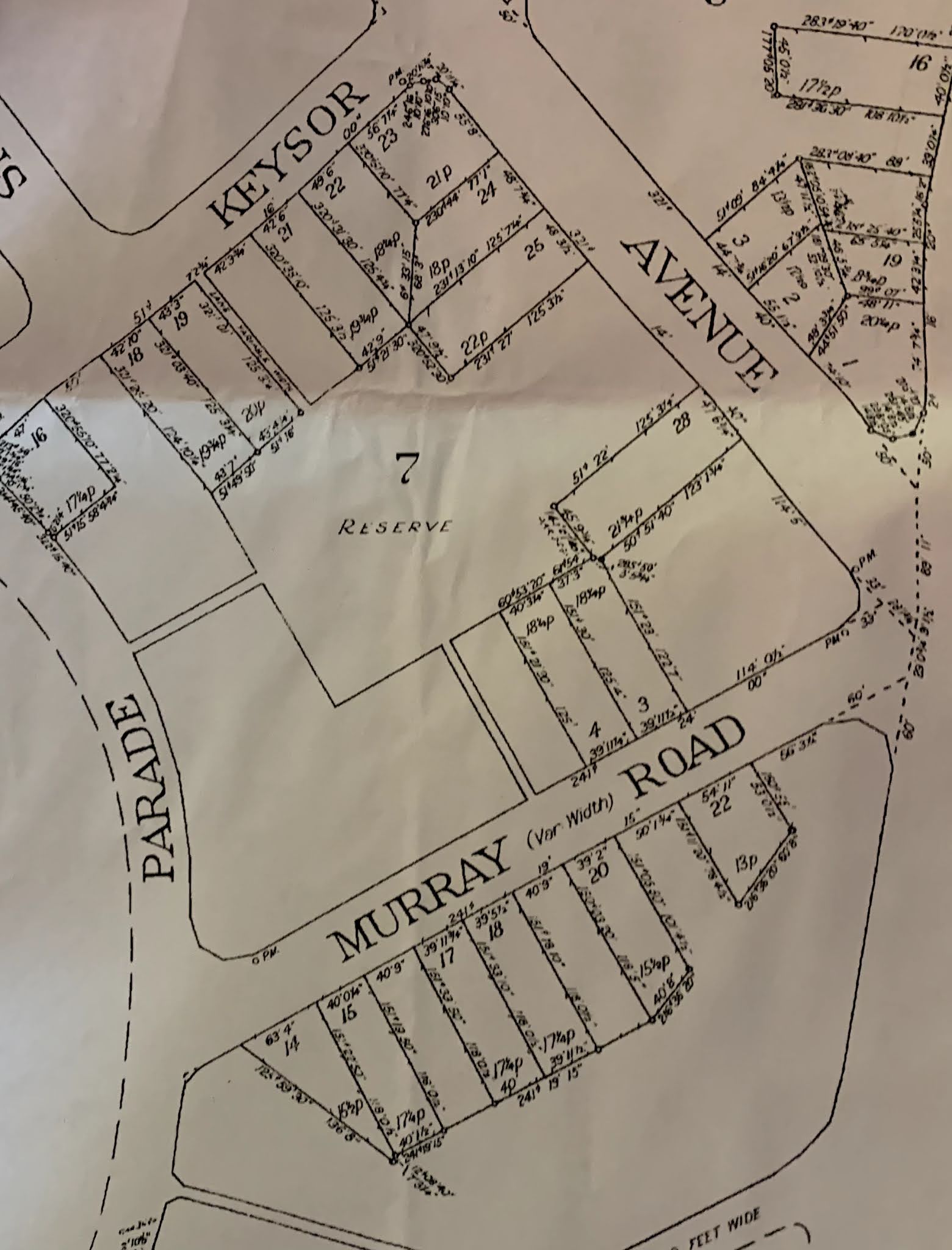
Monday, November 22, 2021
Camberwell Racecourse, Grand Stand and Grounds, c. 1886


Assuming the Club only ever operated one course, I find the 'convenient proximity to town' slightly contentious: 13 km is not a hop skip and a jump although punters could of course take a train to Camberwell and walk a mere three and a half of those km. The Outer Circle Railway, prominent in the plan above but clearly labelled 'proposed', did not open till 1891. Chris McConville's Camberwell Conservation Study (get it here) describes this as the Bowen Estate and gives a slight description of the attractive views available from the site (which would presumably more or less disappear once the villas were built).
The surveyor credited, Bryson, was also an architect judging from items available in the State Library of Victoria. Whoever he was, he apparently had no qualms about producing a remarkably deceptive map of the area suggesting very falsely (unless you had the eagle eye to spot the tell-tale broken line in 'Hollis St') that Burke Road was a lot closer to Bowen St than 900 m.
Who was involved in this project? C. F. C. Taylor, M.L.A. was a very active figure in the area in the 1880s. His day job was as a lawyer, but he was also chair of the Victorian Rowing Association (Melbourne Age 14 August 1883 p.6) and secretary of the Riversdale-Road Omnibus Company (Melbourne Age 20 October 1884 p. 2). Of the other men involved not much can be gleaned and they're probably not important to this story except by dint of their being swept up in this scheme which was almost certainly ill-fated in terms of a racecourse but possibly did alright in the long run when the whole site was made available for housing, if they were able to hold onto it during the 1890s depression. By 1913 there was an aerated water manufacturer called P. G. Dixon & Co (Melbourne Herald 31 July 1913 p. 8) which sold up its Rosslyn St. West Melbourne premises the following year (Melbourne Herald 5 February 1914 p. 5). G. Mayger was involved in some kind of proprietorial fashion with the East Melbourne Bicycle Club (Melbourne Herald 9 January 1891 p. 4). The other names are too common to track.
Friday, November 19, 2021
Boolarra Ave/Eastern Ave, Newborough, Vic.


Original plan at State Library of Victoria.
Tuesday, June 8, 2021
Firmstone Reserve, Pagewood
Declared 8 October 1929. See it here, and read the reviews.
One interesting thing about this space is that its original designer, Geoffrey Robin, envisaged it having quite a wide frontage onto Park Parade. Somebody obviously decided those extra few housing lots were too good to pass up.
This plan is DP16792E NSW State Archives, retrieved by me 9 October 2001
Sunday, June 6, 2021
Marcus Hook/Aston Village in Mare of Easttown

At the risk of seeming like the guy who watches random tv shows and finds internal reserves everywhere, I watch random tv shows, and I find internal reserves everywhere. This is an exception because (1) it's not Finnish! And (2) I thought I found some, but I was wrong, but then I found some.
Right from the very first scene of Mare of Easttown (in the location I think seen above) I thought I was looking at houses which backed on to internal reserve spaces of some sort. Clearly back doors of houses within a block were visible to each other, and somehow between those back doors there was publicly accessible space. However, it wasn't clear - beyond low-rise fences - what was between those back doors. That was, until I went looking at a very convenient website that details (apparently) all the locations of the show. From this I came to appreciate that the place that piqued my interest (above) is actually in Marcus Hook, and constitutes a narrow grid block which has a public pathway down the middle, and very long backyards, but no shared space (aside from the path). You can see it (or at least an example of it) here.
Oddly though before I found the abovementioned website, I went searching in both Aston Township and Chester County. Aston Township features many internal reserve spaces. They include Hidden Park, Aston and Bridgewater Farms Park and Sampson Park also in Aston Township. These don't seem to feature in the show at all (well, I haven't finished watching it yet)...
Update: after watching the entire show, and without wishing to spoil anything, I will say the rear path plays a key role in the denouement of the show. It's very clear that the gardens/yards at the rear of the Marcus Hook blocks are big, empty and essentially useless spaces.
Monday, May 31, 2021
Mitä meistä tuli


In the 2009 Finnish film Mitä meistä tuli (What became of us), two main characters have a special dinner (snails) on their porch in Helsinki.* The shots are only of the two over each other's shoulders but it is clear they are seated in a small private area which opens up into a public, forested area. There is ambient noise of children's (?) play and other conversations in the background, i.e., they are home but they are also in a public space. This image demonstrates the nature of the partitioned porches (there is no doubt another word for these but I can't think of one):


The above image is a better view of the nature of the space - a lawn and dense foliage.
You could be forgiven for dismissing this as merely my fetishisation of Finnish society but also I would like to draw your attention to the way in which this casually (possibly unconsciously as it's so ordinary) explores the way in which a household can go about its private business in public - as one would, I suppose, in a restaurant or going on a walk.
* I don't think Helsinki is stated but if it's not Helsinki it's 'Anycity, Finland'
Monday, May 17, 2021

Wednesday, May 5, 2021
Hundred Houses Homes, Cambridge UK

A plan by C. W. Craske for an estate established by the Hundred Houses Society in Cambridge includes a large playground behind buildings, in this instance from conservationist necessity rather than ideology. ‘The site of a medieval moated farm has been preserved as a children’s playground, and forms a central feature of the scheme, while the rather awkward shape of the site and problems of levels for sewerage have been countered by the use of four culs-de-sac springing fanwise from the children’s playground.’ Craske’s plan appears to have been rejected.
To be honest since I can't locate where it was meant to be, I am not even sure this is an internal reserve - what was adjoining the section at the bottom of this plan?
‘Hundred Houses Society, Ltd.’ Town and Country Planning Vol IV no 13 1935 p.18 (illustration p. 19)
Tuesday, April 6, 2021
'Socialist Housing District in Bucharest'

Currently contextless, as I have to find a way to read the article it's from, by Juliana Maxim, 'Planning the Socialist Housing District in Bucharest and the Soviet influence, 1947–1960' Southeastern Europe 41:2
Monday, April 5, 2021
Jädraås, Sweden

Wednesday, March 31, 2021
Circle Oaks, California
(Arguably this pushes the envelope for what constitutes an internal reserve beyond breaking point. However, this development did include a large amount of open semi-public land between houses. To my mind, the open space behind is the grey area which lets Circle Oaks into the club.)

Portion of subdivision, from https://www.realtor.com/realestateandhomes-detail/Circle-Oaks-Dr_Napa_CA_94558_M28699-24168

Napa Valley Register 30 June 1961 p. 5
A startling new concept of land development for a "new city" for 2,280 homes in Capell Valley was outlined Monday night for the county planning commission and the board of supervisors.The five million dollar project on the former Munson Bros. Ranch south of Moskowite Corners will be known as Circle Oaks and be developed by Herbert H. Kertz of Crescent Park Realty Co., Palo Alto. Legal and engineering aides detailed plans for the first unit of the subdivision containing 237 homes on 175 acres of land.
Circular Lots
The subdivision proposes circular lots with the land between designated as “the common green” or a common recreation area for all homeowners in the area. The common green will include park areas, hiking and riding trails and open areas for resort-type activities.
The circular lots would be two sizes – lots 140 feet in diameter with 15,000 square feet of land and lots 90 feet in diameter with 6,000 square feet of land. The lots would be roughly one acre and one-third acre in size.
The plan envisions that one-third of the land will be assigned to the circular lots and two-thirds of the land would be devoted to the common greens.
According to the development plan, homeowners would acquire deeds to the circular property on which they could place housing to the best advantage of view and terrain, and would jointly own the common recreation area.
The common green would be under the control and supervision of an incorporated improvement association of property owners and a maintenance district would be formed to maintain the area.
Multiple problems were raised by the supervisors, county officials and palnning [sic] commission members.
County Assessor William Johnson and County Auditor Robert Benning were most concerned about the tax responsibility for the common green. Johnson pointed out that if taxes on the common area became delinquent, the property would revert to the state and would have no re-sale value because it would be in unusable strips and odd shapes.
They also raised the question of delinquent assessments for maintenance of the common green, a problem they contemplated as “gigantic” in maintaining responsibility by all property owners.
Assessment?
Circle Oaks spokesmen said the county could take over responsibility for the recreation area and maintain it by assessment, but county officials indicated they were wary of a plan placing the burden of maintaining driveways, utilities and park area on the local government.
The common area would also include an airport, golf course and country club.
Dr. Sterling Cook, director of the Napa County Health Department, was the most vehement opponent of the new subdivision. He said the track had no water supply and no plan for disposal of sewage. “Why do you have to seriously consider a subdivision when there are no plans for water for 2,280 homes and sewage disposal for 2,280 homes?“ Cook asked.
Eugene Miller, soil engineer, contended percolation tests proved septic tanks and leaching fields would be feasible for the area and that ground water could be developed from springs and wells plus a reservoir to catch run-off from rainfall.
In answer to Dr. Cook’s question, Miller said six percolation tests had been made for the first 238 lots on the first 175-acre unit.
Each to Qualify
John W. Cone, director of urban planning for Riches Research Inc., employed by Crescent Park Realty Co., said no buildings would be constructed until each site qualified under state and county requirements for water and sanitation.
County Counsel Daniel K. York referred to the common greens as a “no man’s land” that would be fraught with problems of tax delinquency. He and Supervisor Howard Dickenson proposed the land be divided up into private ownership with the circles as a building site giving easements to remainder of the lot owners for common purposes.
Cone said this would defeat the purpose of the common green based on the psychological difference in common ownership.
Because of the hilly terrain of the country, he said, the circulat lots take best advantage of available home sites.
York said, “We formerly believed every subdivision should have recreational lots for playgrounds. They are all uniform now in that they are grown up in weeds. You’ll leave the county in an exposed position in which to cope with land outside the circles. They go tax delinquent and are sold to the state for taxes. Then there’s no re-sale value.”
The problem was not resolved.
Kertz told the county officials that he had already taken 50 deposits for homes and that “everyone” understood his responsibility for the common green and was more than willing to undertake to support and maintain the area.
Open Space
Cone explained the common green as a park-like open space in the centre of a neighborhood or smaller group of houses and apartments. Its lawns, tree-shaded walks, gardens and play areas are available to all surrounding residents for common use and enjoyment.
He said the idea was over 80 years old and has a forerunner in the New England village green. He cited as examples of contemporary developments the use of the concept at Radburn, N. J., Greenbelt, Md., and Baldwin Hills in Los Angeles. He said Baldwin Hills Village proved highly successful on 80 acres and Greenwood Common in Berkeley provides 12 lots around a pleasant common green within a two and one-half acre parcel.
He said the concept is endorsed and under study by such groups as the Santa Clara Planning Department, American Society of Planning Officials, and has been used in principle in the Golden Gate Development in San Francisco.
The supervisors reached no conclusion and made no recommendation to the planning commission, which will consider the tentative map of the subdivision at its meeting Aug. 7.
Cone said the Circle Oaks principals would be glad to schedule further meetings to discuss the necessary public improvements of county water, streets and other improvements through assessment districts.
In order to permit the circular lots they request the planning commission to waive certain zoning ordinances regarding lot sizes, frontage and depth requirements.
Astrid Edington, ‘New Concept for Land is Unfolded’, Napa Valley Register 1 August 1961 pp. 1-2

View it here
Tuesday, March 23, 2021
Industrial town project, Federal Terratory, (sic) Australia

I could be wrong but I think one or two of these internal reserves actually follow the course of creeks, which is unusual for the Griffins though pragmatism was not unusual in their work. The city centre detail is below.

Tuesday, February 16, 2021
Karppi, aka Deadwind, at Puu-Käpylä

Usko is a taxi-driver, which I am going to guess in Finland as elsewhere is something of a blue collar job, and his wife Anna is a high profile (?!) social worker acting as a consultant to a major enviro-developer. I figure that there is a slight subtext here that Puu-Käpylä is one place where two people of very different socioeconomic backgrounds might live. That said, this is never identified as Puu-Käpylä.
 Spoiler: the final episode of the first series gives what I believe to be a false impression, that these houses are joined together in their basements. I guess I could be advised otherwise but even in the show it seems to be something that has to be explained as an anomaly, so I am going to assume it's not real.

I also doubt that the image above necessarily corresponds to the aerial shot, which is used many times in the show. Here is a link to Puu-Käpylä however if you want to try and locate it.
Subscribe to:
Posts (Atom)
Kabbera Central, Kelso, NSW
Look at it here. Kelso is essentially a suburb adjoining the regional city of Bathurst but it has an identity greater than mere adjacent su...

-
 A search on something else entirely led me to the June 1927 issue of one of Florence Taylor's publications, Construction and Local Go...
 -
This reproduction of Lars Sonck's second prize-winning entry for Töölöö appears on page 373 of Helen Porfyriou's 1990 thesis Scandi...
-
 Comparison between the above from a relatively new UBD street directory and the current Google Map shows some disparity in the shape of t...
