
Tuesday, March 22, 2016
Unnamed reserve between Over Dam, Francis Davant, Grace Park; Habersham, South Carolina
Sunday, March 20, 2016
Balrampur, India

Word is none of Geddes' Indian plans were ever realised, but have fun looking in Balrampur.
Friday, March 18, 2016
Belgian Congo Film Image

Wednesday, March 16, 2016
Talpiot (Talpioth), Jerusalem
At least two internal reserves here (slightly to the right of the middle), perhaps more - the two obvious ones might be to the right of a group of four. Note the orientation of this plan is sideways. See the area as built (not very closely to this design) here; there may be one IR in this suburb, south of Ein Gedi St/ west of Efrata St, but satellite pics of Israeli urban areas are never very clear. 
'Talpiot was... planned by Richard Kauffmann, who came to Palestine from Germany in 1920 at the invitation of Arthur Ruppin, a Zionist thinker and leader, and one of the founders of Tel Aviv. Under the British Mandate Kauffmann was one of the chief actors in the planning of agricultural and (sub) urban Jerish settlements. It was in this context that garden city inspiration was most evident in Palestine, especially from the 1920s onward... Although Kauffmann's original plans were not fully implemented, they bore the influence of garden city rhetoric and an explicit vision of Talpiot as a "suburban garden city"'.
Yossi Katz and Liora Bigon, 'Urban development and the "garden city": examples from late Ottoman-era Palestine and the late British Mandate, in Bigon and Katz (eds) Garden Cities and Colonial Planning: Transnationality and urban ideas in Africa and Palestine Manchester UP, 2014, p. 151-3
See this website for more on Kauffmann.
Tuesday, March 15, 2016
Proposed T. B. Village Settlement, Picton Lakes, NSW

The Sydney Morning Herald announced the competition in retrospect on 6 April 1927 open to 'students of architecture at the University and Technical College'. Infuriatingly (or is that putting it too strongly) I can find little further evidence of the competition (and unsurprisingly, this plan was never brought into being). But the village did exist, in Couridjah; here's a slightly earlier announcement of building industry involvement in the creation of housing stock, from the Sunday Times of Sydney on the 15 August 1926 (p. 2):

Back to the plan: Duncan McPhee Smith, the winner from 14 entrants, was a twenty-year old Sydney Technical College student employed in the office of John Reid. In fact (we are told in the Picton Post for 22 June 1927, p. 2) Smith won not only the prize for best layout but also separate prizes for an administration block design and a chalet. This item also confirms that the Smith layout involves internal reserves (I count 25 blocks, many of which surely have internal reserves, but it's not entirely sure what each section is coded to represent): 'the architect has arranged... that each home will radiate around a Central Village Green.'

In 1928, Duncan McPhee Smith graduated and received a travelling scholarship - the Byera Hadley Scholarship - 'to assist the winner in undertaking postgraduate studies in one of the capitals of the Commonwealth, Sydney excepted' (Sydney Morning Herald, 4 August 1928 p. 16). He chose to use these funds to study town planning in Adelaide and died in 1987.
I'm unsure where the Picton Village was actually located; using South St. Couridjah as a bearing, though, I'm assuming that McPhee Smith's plan was intended to be laid out in this general area.
Monday, February 15, 2016
Unnamed reserve, Molendinar, Queensland
With some time to spare on the Gold Coast after the highly successful Urban History Planning History Conference, friend of the blog Victoria Kolankiewicz and I decided to try and find an internal reserve in the general area. This was the one we plumped for. It's noted on google maps as 'Molendinar Power Station' but in general displays as a green open space linked from surrounding (light industrial) streets by green walkways. Here's one of them:

Some of the land is plainly drainage reserve, with these covered channels at the end of said walkways:

The main game is the Molendinar power station, and all power lines lead there:

Some of the flat open space surrounded by (industrial) buildings. I also saw a couple of wallabies in the space, for what that's worth (and not surprising of course).


The actual power facility, nothing much to see.


Same walkway as before.

So... Barry Humphries had a show in the early 70s, which if I remember rightly was called At Least You Can Say You've Seen It. Victoria and I can now claim that right. More information forthcoming, if anyone ever supplies me with any.
Wednesday, January 27, 2016
Mayfield Park - three extra snippets of information
From a newspaper known as the Dandenong Journal, largely pertaining to the Glen Alvie estate which was located close to Mount Waverley railway station (there is a bit of almost-readable material about it on Mount Waverley's wikipedia page).
Glen Alvie itself has some internal reserves; look at the odd arrangement around Sherwood Road and there is also a more conventional IR in Winbourne Road to its north-west. It is the local progress association which is promoting discussion re: major open space in the area and pressing council to find a large recreation area. Mayfield Park fits the bill. No particular explanation of why it should then be an internal reserve-styled space, though Glen Alvie is setting a style there.
Dandenong Journal 19 May 1948 p. 8
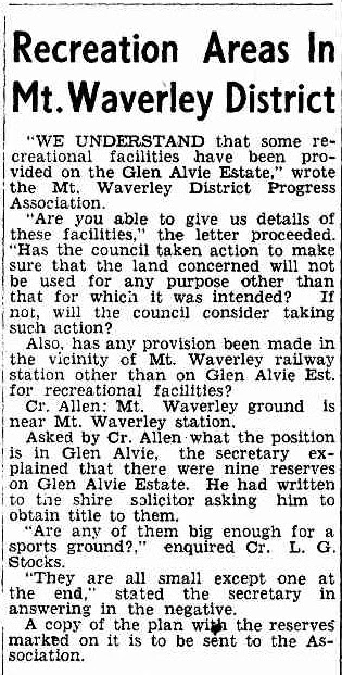
Dandenong Journal 9 June 1948 p. 5
Same as above - Dandenong Journal 9 June 1948 p. 5
Subscribe to:
Posts (Atom)
Kabbera Central, Kelso, NSW
Look at it here. Kelso is essentially a suburb adjoining the regional city of Bathurst but it has an identity greater than mere adjacent su...

-
 Comparison between the above from a relatively new UBD street directory and the current Google Map shows some disparity in the shape of t...
 -
 Now for something different: the industrial internal reserve. Two examples of this lie within the northern portion of Griffin’s Milleara Est...
 -
 A search on something else entirely led me to the June 1927 issue of one of Florence Taylor's publications, Construction and Local Go...