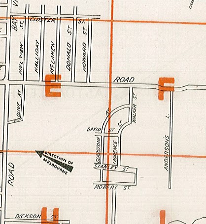
It's not much of a story (at this point, anyway!). It possibly starts here:
Melbourne Argus 21 April 1955 p. 17
Or perhaps it starts here:
Or both. Essentially, it's the usual urban creep narrative. Here is another map, ostensibly from the '1960s' (which is a long period of time, and I'm still not sure I believe that the Gladstone/David/Walker/Laurence/Stanley/Robert streets were ever built):
N. R. Reid & Co; from the State Library of Victoria. View the whole thing here.
(Update 15 February 2016: this marvellous site shows quite clearly that these streets did not exist in 1945. If they ever did exist it was for an extraordinarily short period of time!)
The first map above is from my Morgan's Official Street Directory [of] Melbourne and Suburbs, which is undated but is probably late 1940s/early 1950s, and I am assuming that Mayfield Park the farm was here somewhere in the middle of the crescent formed by Laurence Street. I'm only assuming that because it is roughly the location of the present-day Mayfield Park (the park/ sports reserve) as seen in this from Map 75 of a Gregorys street directory from probably around 1977 or '78 (note the inclusion of McLaren, Donald and Howard streets for orientation):
So here, you can see why Mayfield Park the park is of interest to me: it's a large open space apparently bounded on all sides by housing/buildings. Check the current state of the place; it is largely the same.
I can only speculate (as a lot of the speculators who caused the above craziness might also have said) as to what happened here. Obviously the originally proposed Gladstone Ave/ David Street/ Laurence St subdivision in the Morgan's directory was never constructed (its form suggests it was a much bigger enterprise, too - if we assume the idea is to mirror those crescents south east of Walker Street). The Stanley Street/ Robert Street alignments look like an intrusion from another idea altogether, suggesting a few grand ideas from a few grand men about forty years (?) too early. (By the way, a very detailed account of a tragic airplane disaster in the Melbourne Argus of 9 June 1936, p. 17 makes it clear that not only was Anderson's Lane very much in existence at this time - I'm guessing it roughly follows the alignment of present-day Bales St - but it had telephone wires on it, these being the apparent cause of the air disaster in question).
The reason that I make a point about the messy subdivision rubbish in this area prior to the creation of Mayfield Park is that I suspect this was part of the reason for the creation of the park - either speculators moved in and bought land there but were unable / unwilling to continue to pay rates on it, or for some other reason it ended up in the hands of council, as per the Sunshine example detailed recently. I am imagining that some enterprising council employees saw the opportunity to provide open space in the area and heighten the amenity for the surrounding subdivisions. You should also compare the Gregory's map and the present-day Google Map as far as the open space areas adjoining Pamela, Bernard, Cora, and Bales are concerned - all one big space now, stretching east.
Of course the creation of the Mulgrave Freeway (1972; now a part of a bigger enterprise, the Monash Freeway) made the greatest changes of all in this area, bisecting a suburb and changing the social climate either side. I would love to read the documentation on the way that the City of Waverley (as it was up until 1994) braced itself for the changes the Freeway would make to its communities. A lot of streets were lost in the construction of that Freeway... although many of them were surely only streets on paper.


No comments:
Post a Comment