Tuesday, January 26, 2016

Mayfield Park, Mount Waverley Vic.

https://goo.gl/maps/5U2qf2o1hbR2

It's not much of a story (at this point, anyway!). It possibly starts here:

Melbourne Argus 21 April 1955 p. 17

Or perhaps it starts here: 


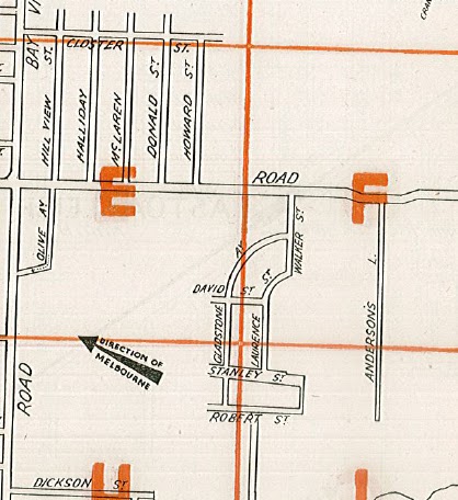
Or both. Essentially, it's the usual urban creep narrative. Here is another map, ostensibly from the '1960s' (which is a long period of time, and I'm still not sure I believe that the Gladstone/David/Walker/Laurence/Stanley/Robert streets were ever built): 

N. R. Reid & Co; from the State Library of Victoria. View the whole thing here

(Update 15 February 2016: this marvellous site shows quite clearly that these streets did not exist in 1945.  If they ever did exist it was for an extraordinarily short period of time!)

The first map above is from my Morgan's Official Street Directory [of] Melbourne and Suburbs, which is undated but is probably late 1940s/early 1950s, and I am assuming that Mayfield Park the farm was here somewhere in the middle of the crescent formed by Laurence Street. I'm only assuming that because it is roughly the location of the present-day Mayfield Park (the park/ sports reserve) as seen in this from Map 75 of a Gregorys street directory from probably around 1977 or '78 (note the inclusion of McLaren, Donald and Howard streets for orientation):


So here, you can see why Mayfield Park the park is of interest to me: it's a large open space apparently bounded on all sides by housing/buildings. Check the current state of the place; it is largely the same. 

I can only speculate (as a lot of the speculators who caused the above craziness might also have said) as to what happened here. Obviously the originally proposed Gladstone Ave/ David Street/ Laurence St subdivision in the Morgan's directory was never constructed (its form suggests it was a much bigger enterprise, too - if we assume the idea is to mirror those crescents south east of Walker Street).   The Stanley Street/ Robert Street alignments look like an intrusion from another idea altogether, suggesting a few grand ideas from a few grand men about forty years (?) too early. (By the way, a very detailed account of a tragic airplane disaster in the Melbourne Argus of 9 June 1936, p. 17 makes it clear that not only was Anderson's Lane very much in existence at this time - I'm guessing it roughly follows the alignment of present-day Bales St - but it had telephone wires on it, these being the apparent cause of the air disaster in question). 

The reason that I make a point about the messy subdivision rubbish in this area prior to the creation of Mayfield Park is that I suspect this was part of the reason for the creation of the park - either speculators moved in and bought land there but were unable / unwilling to continue to pay rates on it, or for some other reason it ended up in the hands of council, as per the Sunshine example detailed recently. I am imagining that some enterprising council employees saw the opportunity to provide open space in the area and heighten the amenity for the surrounding subdivisions. You should also compare the Gregory's map and the present-day Google Map as far as the open space areas adjoining Pamela, Bernard, Cora, and Bales are concerned - all one big space now, stretching east.

Of course the creation of the Mulgrave Freeway (1972; now a part of a bigger enterprise, the Monash Freeway) made the greatest changes of all in this area, bisecting a suburb and changing the social climate either side. I would love to read the documentation on the way that the City of Waverley (as it was up until 1994) braced itself for the changes the Freeway would make to its communities. A lot of streets were lost in the construction of that Freeway... although many of them were surely only streets on paper.

Saturday, January 16, 2016

Trystan Edwards

From Robert Freestone who says only that it is 'Trystan Edwards, 1934'. More information as it comes to hand. 


Thursday, January 14, 2016

Tennis Courts in block bounded by Devonshire, Cornwall, Thomsons and Una Streets, Sunshine, Victoria

Victoria Kolankiewicz alerted me to this unusual space this afternoon: a block in the Melbourne suburb of Sunshine within which two 'roads' (unnamed, probably better termed lanes) run alongside what I assume is a public open space containing tennis courts.

A search in the digitised newspapers reveal nothing of consequence regarding the designation of the space for recreation aside from the information that Una Street, which it should be assumed was created at the same time as the block in question, dates back to at least 1937. Here is a mention of it in the Sunshine Advocate from 8 October 1937, p. 6, in which it is apparently being repaired by council:


It would be sensible therefore to assume that the block dates back to the first half (at least) of the 20th century. But curiosity got the better of me and I decided to spring for the original subdivision plan:


The confusing part is not the plan per se (though that's not exactly a common format for a suburban subdivision) but the date on it: it was lodged on 31 March 1960.

Note no designated purpose for the large central space ('lot 9') and the 'roads' are clearly far too narrow to be anything other than lanes (though Google Maps suggests that they allow for road access!). I'll have to visit this site soon, at which time I'll have more to report and can add to this information.

UPDATE:

My trusty Morgans Official Street Directory Melbourne and Suburbs from some indeterminate (but pretty guessable) late 1940s time reveals that the site was, at one time, crossed by two roads, Shelley Street and Byron Street: (this is map 59, by the way):


The Sunshine Advocate for 19 January 1951 (p. 1) tells us this:


The next step might be to advertisements like the one appearing in the Advocate on 15 December 1950 (p. 5) which gives us some detail on the size of the 'small lots' in question (as small as 20x55 ft) as well as the names of the former owners, all of whom apparently defaulted, and who I'd love to spend some time tracking down - maybe in the next life. Meanwhile, the origin mystery is largely cleared up: Sunshine Council appears to have resubdivided in the late 1950s and concentrated purely on street frontage. Council may have trumpeted its benevolence in dedicating the space at the rear of the four housing lots in Una and Devonshire to public recreation, but the digitised newspapers of Trove largely run out at about 1960, so that is not an easy 'get', nor is it really a sure one.

UPDATE # 2: Mystery solved (by Victoria, who gets the prize for being a snake that eats its tail). From the online History of the Sunshine Parish:
Land in Devonshire Road had become available to the Parish and the opportunity was taken up with the idea of making provision for youth recreation.  Four en tout cas tennis courts were built and opened in 1960.  Three years later the Duke of Norfolk (who was in Australia with the touring English cricket team) opened the Youth Centre Building, the lit basketball courts and the cricket practice wickets.  The portions of land not built on were sold off to help finance the project.  

Monday, January 4, 2016

Hampstead Garden Suburb: A Conservation Study (1971)


Hampstead Garden Suburb: Plan for Conservation (subhead on cover is 'A Conservation Study'): Consultants' report to The New Hampstead Garden Suburb Trust Ltd Shankland Cox & Asssociates April 1971 p. 22, 23 excerpts. 

Tuesday, September 29, 2015

City Planning, Perth 1965-1967 by Paul Ritter

P. 79 of this fascinating tour de force. I'll put aside the typification of internal reserves as 'Radburn greens' for another day.

Monday, September 28, 2015

McAdam Reserve, Northcote, Victoria


This is almost certainly an ad-hoc space created by the demolition of some building or other – probably, given the space’s onetime working class status, a small backlane business – I’m thinking a dairy or something similar. In any case, it is not a ‘classic’ internal reserve given that it has access by one footpath from Stanley Street, but then also by two laneways which could technically allow vehicle access (though there’s nowhere for a vehicle to actually stop). It was almost certainly not a part of the original plan for the area.

The playground is very well stocked. Barbeque, climbing equipment, etc. What is most interesting from our point of view is that on the Saturday morning I visited, it was occupied by the perfect users: five children, four adults, the adults almost certainly being parents to the children. Two backyard gates were open into the space, suggesting that these users were very local (I should have asked them. I didn’t want to intrude on families enjoying a shared and semi-private resource).


I’ll go back at another time and see what other uses it might have. All surrounding properties have high fences, suggesting there is no particular surveillance going on here. But otherwise, a very fine example – the kind of IR we’d like to see.

See it on google maps here

Update 15 Feb 2016: Much to my surprise I see from this site that the above surmise about the reserve being created by an absence might well be quite wrong, or at least: it was a space in 1945. Then, the reserve was twice the size and had an entrance on Westgarth Avenue which has since been filled with housing. Thanks to Robert Freestone for alerting me to Melbourne, 1945 - if ever there was an argument for a user-friendly interface this is it. 

Saturday, September 26, 2015

Hartlands Road Internal Reserve, East Ivanhoe, Victoria


This small reserve is triangular in shape and is located behind houses built on typical suburban allotments in the affluent suburb of East Ivanhoe, above the Yarra River in suburban Melbourne.  Its shape results from it being bounded by Hartlands Road, Lower Heidelberg Road and the gentle curve of Withers Street.
This area was part of the 313 acre Hartlands Estate, originally purchased by Sylvester John Brown, the father of novelist, “Rolf Boldrewood”, and only slowly succumbed to the auctioneer’s hammer in the middle of the 20th century when Burke Road North was pushed through to meet Lower Heidelberg Road.
However the frontages to Lower Heidelberg Road appear to have been sold by the 1930s as the majority of houses here date from late in this decade, while one house, in Hartland Road, is a Californian bungalow and may well date to the late 1920s.
The radial pattern of streets centred on the vegetated roundabout at East Ivanhoe, although incomplete, is distinctive.  The Heidelberg Conservation Study says that Peter Tuxen designed part of the nearby Chelsworth Estate in 1902 and it is possible that this area was also his work or that of his nephew, Saxil Tuxen, who is well known for providing internal reserves in his geometrically patterned subdivisional designs.   To the immediate north are the Mount Eagle Summit Estate (1914) and the Glenard Estate (1916) which were designed by Walter Burley Griffin for landowner and developer, Peter Keam, and which featured internal reserves.  Saxil Tuxen worked with Griffin on the Ranelagh Estate, Mt Eliza, in 1924 and there is a further connection with the Sharp family, timber merchants of South Melbourne who lived in Ivanhoe, who were connected with Tuxen’s Park Orchards subdivision.
The reserve is approached by a narrow “neck” from Hartlands Road, across which is a wire gate with the City Of Banyule logo on it, suggesting that, unlike Griffin’s Eaglemont Estates, this one is owned by the municipality.   12 houses abutting the park proper have access to it via back gates, while another four properties have access via the “neck”.  This leaves half a dozen properties in the block- on the corners- having no direct access.  The useless acute point at the north end reveals a shortcoming of the triangular design.
Fenced boundaries are universal, however, in the park proper, there are some transparent fence types and dense plantings conceal some of the boundary fences, resulting in a very pleasant ambience.  The “neck” is used for car access to abutting properties and it is possible to gain others by driving across the park, however this does not seem to be done in practice and the reserve is given over to a broad grassy sward with tree cover and native shrub beds.
The reserve is in excellent condition and is very well maintained, with much evidence of revegetation having taken place in recent years.  The central area appears to be used for children’s games and there are several seats and tables, which suggest common usage by the residents, as does a wok-shaped hotplate for a fire pit.  There are several stacks of firewood, which may be for this or for the residents’ own home fires.  Significantly, there is a ride-on mowing machine under a cover, which suggests that the residents themselves maintain the grass in this attractive and successful internal park reserve.


Steven Barlow September 2015

Kabbera Central, Kelso, NSW

Look at it here.  Kelso is essentially a suburb adjoining the regional city of Bathurst but it has an identity greater than mere adjacent su...